While I am still unable to fully convert the dBase files into SQL scripts automatically, I have decided to start expanding on the data I already have.
Since Cameron Research Center is much smaller, less complex, and has fewer rooms I have decided to start digitizing the building elements like I did for Woodward hall. I was able to create feature classer for each floor's rooms (polygons) and still need to digitize hallways and elevators.
I will then take the much simpler table from this building and begin exporting it into a Oracle database. I also need to start looking for ways to automate these processes.
Wednesday, April 9, 2008


Tuesday, April 8, 2008
dBase to SQL Issues
In order to export the geodatabase, I must first convert the files to dBase and read them in a third party program. Once I have the registered version I will be able to convert directly to SQL scrips or .CSV files.
The one problem that I am facing now is that the ObjectID field, which is a primary key, does not convert over to dBase format. It's of type "objectid", which, when displayed in DBF Manager only shows up as zeros. I will have to find a way to assign object ID's in a different type so they can be transferred over.
The one problem that I am facing now is that the ObjectID field, which is a primary key, does not convert over to dBase format. It's of type "objectid", which, when displayed in DBF Manager only shows up as zeros. I will have to find a way to assign object ID's in a different type so they can be transferred over.
Sunday, April 6, 2008
Future Goals, Database Info
Next week I plan on starting the Geocoding aspect of the project. The first thing I will do is consult with Dr. Paul Smith about possible methods. i will then add entries to the MAT in order to put points on the map where I need them. I will most likely have to manually do this. After this is done, I will have to explore more options in implementing the data in 3D.
I also want to export the database so that SQL calls can be made programmatically.
If I can get all of these things done I will have a good week....
I also want to export the database so that SQL calls can be made programmatically.
If I can get all of these things done I will have a good week....
Monday, March 31, 2008
Combining 2D and 3D data through Geodatabase
I stumbled across an interesting powerpoint presentation from the UC ESRI Conference in 2007. It's about a hybrid data model for fire evacuation and is very similar to the project I am currently working on. It was proposed by Inhye Park from the University of Seoul, Korea.
The "hybrid" model proposes that a 2d environment maintained in GIS and a 3D environment created somewhere else, all linked together through the Geodatabase using SQL calls.
Here is an example from the presentation:
 The first part, converting the CAD files to Geodatabase files, I have already completed. The database has been build, but we have yet to link it to any other 3D data models yet. This is what we hope to accomplish in the coming weeks.
Below is a graphic depicting how the model will work once completed:

The "hybrid" model proposes that a 2d environment maintained in GIS and a 3D environment created somewhere else, all linked together through the Geodatabase using SQL calls.
Here is an example from the presentation:
 The first part, converting the CAD files to Geodatabase files, I have already completed. The database has been build, but we have yet to link it to any other 3D data models yet. This is what we hope to accomplish in the coming weeks.
Below is a graphic depicting how the model will work once completed:

Wednesday, March 26, 2008
Interfacing with existing Mecklenburg Master Address Locator
I have obtained the master address locater for Mecklenburg county. This data is stored in a shapefile as point features with a large amount of database info. Each point on the map below represents an address that has been geocoded, the table beside of it represents the attribute data for that specific address:

I will use this existing data to create the references to indoor locations. I believe by giving each room a point in the address locater, it will be possible to do query's and other such data manipulation with the indoor data. Since I already have the point locations for Woodward hall it will be as simple as copying and pasting the points into the Master Address table and updating the attribute information.
Since there is no "standard practice" for indoor geocoding I will have to develop a model to use that will enable me to do query's and location analysis the same way as regular addresses.
Once this is finished I should be able to facilitate route finding indoors by not only selecting points in space, but also by running queries on the location name or room number itself.

I will use this existing data to create the references to indoor locations. I believe by giving each room a point in the address locater, it will be possible to do query's and other such data manipulation with the indoor data. Since I already have the point locations for Woodward hall it will be as simple as copying and pasting the points into the Master Address table and updating the attribute information.
Since there is no "standard practice" for indoor geocoding I will have to develop a model to use that will enable me to do query's and location analysis the same way as regular addresses.
Once this is finished I should be able to facilitate route finding indoors by not only selecting points in space, but also by running queries on the location name or room number itself.
Tuesday, March 25, 2008
Goals for this week...
Today I have mainly been collecting datasets and other things so that I can continue making improvements to my prototype. The first thing that I have now is a coverage that has the latest street centerlines. However, it seems to not be entirely complete for UNCC so I will have to later change it to a shapefile so I can add roads to it. It will also be unnecessary to build a network from the shapefile in order to do analysis on it.
I also need to start the process of creating the hallway networks in GIS. For now I am only going to focus on just the centerline shapefiles and creating a network out of them, then connecting them to the existing street centerline files.
If time allows, I also need to clean up the work I did previously and correct some alignment issues that I have been having.
I hope to start following a new data model that I have stumbled upon on the web. It's referred to as the Building Information Spatial Data Model (BISDM) and relates to indoor GIS applications. I am sure that this will come in handy in the future, the link is http://bisdm.org/information/
I also need to start the process of creating the hallway networks in GIS. For now I am only going to focus on just the centerline shapefiles and creating a network out of them, then connecting them to the existing street centerline files.
If time allows, I also need to clean up the work I did previously and correct some alignment issues that I have been having.
I hope to start following a new data model that I have stumbled upon on the web. It's referred to as the Building Information Spatial Data Model (BISDM) and relates to indoor GIS applications. I am sure that this will come in handy in the future, the link is http://bisdm.org/information/
Tuesday, March 18, 2008
Server backups, shapefile conversions, and progress on network creation
Now that I finally have an account on the Vis Center server, I have backed up all of my database files and other pertinent information there. I will be periodically updating a copy of the database each week.
I have also taken all of the feature classes and converted them into shapefiles so that Jianfei can use them for his program. These are stored on the server and on the local machine under the directory 'shapefiles'.
I have begun to create networks for each floor. I have finished the first floor and everything seems to be working well. I have been able to use the find route commands and map routes to rooms from the outside doors. The next step will be to create this data for each floor and somehow have them link up. This may be possible by inputting elevation data in the network.
Here are some screenshots of what the network dataset looks like along with the floor one datasets:
 And here is a screen of the network by itself, the dark line indicates the shortest route between two points:
 It's important to note that in order to maintain connectivity you have to have connections at endpoints connections along edges that are continuous will NOT WORK!! I tried this earlier by drawing whole line segments for hallways but it did not work since each connection point has to be an endpoint for connectivity to work correctly. Without this route finding will be erroneous or will not work at all.
I have also taken all of the feature classes and converted them into shapefiles so that Jianfei can use them for his program. These are stored on the server and on the local machine under the directory 'shapefiles'.
I have begun to create networks for each floor. I have finished the first floor and everything seems to be working well. I have been able to use the find route commands and map routes to rooms from the outside doors. The next step will be to create this data for each floor and somehow have them link up. This may be possible by inputting elevation data in the network.
Here are some screenshots of what the network dataset looks like along with the floor one datasets:
 And here is a screen of the network by itself, the dark line indicates the shortest route between two points:
 It's important to note that in order to maintain connectivity you have to have connections at endpoints connections along edges that are continuous will NOT WORK!! I tried this earlier by drawing whole line segments for hallways but it did not work since each connection point has to be an endpoint for connectivity to work correctly. Without this route finding will be erroneous or will not work at all.
Friday, March 14, 2008
All feature classes are now finished
I have just finished creating all of the feature classes that I set out to do earlier. Everything has come together quite well, with the exception of a few alignment issues in the 3D view. I have all 4 floors correctly represented with feature classes for hallways, stairways, elevators, and rooms. Here is what the final result looks like:

After removing the rooms layers a nice view of the transportation structure of the building is provided. Here is a screenshot of how that looks:
 Now that I have this completed, the next step be creating a geometric network that represents the same thing with line features. Then we will be able to do analysis and route finding.

After removing the rooms layers a nice view of the transportation structure of the building is provided. Here is a screenshot of how that looks:
 Now that I have this completed, the next step be creating a geometric network that represents the same thing with line features. Then we will be able to do analysis and route finding.
Monday, March 10, 2008
New feature classes for hallways, stairways, and elevators
Today I have updated the database to include 3 new feature classes: Hallways, Stairways, and Elevators. I have annotated them correctly and only need to finish floors 3, 4, and 5.
I am currently waiting for Joel to come up and install ArcInfo, then I will be able to expedite the process of creating and editing the feature classes.
I am currently waiting for Joel to come up and install ArcInfo, then I will be able to expedite the process of creating and editing the feature classes.
Thursday, February 28, 2008
3-D data representation
Today I have been working on representing and displaying my data in 3-dimensions. I wanted to do this just as a proof of concept that the 3-D generation will work properly with my datasets.
I only have 2 floors at the moment, but the 3-D display in ArcScene is stunning.
Here are some screens I took today:
Floor 1 in 3D:

Floor 2 in 3D:

Composite:
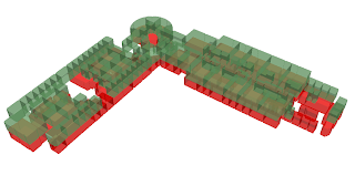
Composite with orthophoto reference:

I only have 2 floors at the moment, but the 3-D display in ArcScene is stunning.
Here are some screens I took today:
Floor 1 in 3D:

Floor 2 in 3D:

Composite:

Composite with orthophoto reference:

Subscribe to:
Posts (Atom)
