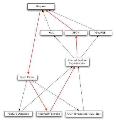
This software also is able to use a PostGIS as it's storage and information mechanism. In addition to this, there are several options for input/output:
- GeoJSON -- input and output in the emerging GeoJSON specification. FeatureServer supports GeoJSON Points, Lines, and Polygons with Rings, as both input and output.
- GeoRSS Atom (Simple) -- input and output of Points/Lines/Polygons (no rings/holes) in GeoRSS Simple (Atom). This allows one to take any GeoRSS Simple Atom feed and feed it to FeatureServer for storage.
- KML -- Input and output of Points, Lines, and Polygons from KML.
- GML/WFS -- Output-only support of WFS/GML.
- HTML -- Output-only support of features as HTML files, powered by Cheetah templates.
- OSM -- Output-only support of features as OpenStreetMap '.osm' files. (These files can be opened using JOSM and posted to the OSM server.)
As soon as I am able to get a test machine up and running with the new version of Postgresql I will be able to install these things and test them out. Then we can begin developing methods to transfer this information over to a format that will be displayed properly on an iPhone.
The image below shows the framework of the featureserver and the many storage and input/output options:


No comments:
Post a Comment