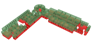
Today I have been working on representing and displaying my data in 3-dimensions. I wanted to do this just as a proof of concept that the 3-D generation will work properly with my datasets.
I only have 2 floors at the moment, but the 3-D display in ArcScene is stunning.
Here are some screens I took today:
Floor 1 in 3D:
Floor 2 in 3D:
Composite:
Composite with orthophoto reference:
Thursday, February 28, 2008
Wednesday, February 27, 2008
Dataset progress, solution for storage
I have finished the second floor polygon feature class and have most of the rooms generally annotated. I am happy to say that everything is geocoded and fits perfectly where it's supposed to be.
Right now I'm waiting on ITS to install ArcINFO so I can start creation/maintenance of my geometric networks. In the meantime I am going to be finishing things up on the rest of the datasets and annotating them properly.
My biggest concern at the moment is I have no place to store the geodatabase other that my local machine. This is a problem, since this is a shared computer, who knows what might happen to my work. I also need to get my datasets out so that my other colleagues can work and edit them. Since it's not as simple as just emailing a dataset, I need some way to store the geodatabase on a server and allow FTP capabilities. This is something I hope to resolve by Friday's meeting. I would rather not have my data on a local machine over Spring Break.
In conclusion, here is a great shot of what the completed polygon feature classes look like overlayed on the orthos with roads as another layer:
Tuesday, February 26, 2008
Progress on room polygon feature class and georeferencing
Today I focused mainly on georeferencing all of the files that I have into NAD1983 Coordinate system. I have completed a good deal of this work, and am now focusing on extracting room polygons from the CAD data and pasting them in their own feature class in the geodatabase.
The room polygons have been extracted form the CAD files and this is what it looks like:
I have also updated the database to reflect the room numbers and brief descriptions of each room. The process was rather painstaking and involved using the predefined polygons from the CAD files and copying them over into a new feature class in my database. I then used the CAD files to determine room numbers and other information. The areas of the rooms nearly match perfectly with the polygons in my feature class with only a few hundredths of a degree of error, which is to be expected.
The next step is to create the line features and convert them into a geometric network. This will allow me to focus on the big picture.
Subscribe to:
Posts (Atom)